Weather Alert in California
Flood Warning issued February 24 at 7:46PM PST until February 25 at 7:00AM PST by NWS Eureka CA
AREAS AFFECTED: Mendocino, CA
DESCRIPTION: ...The National Weather Service in Eureka has issued a Flood Warning for the following rivers in California... Navarro River at Navarro affecting Mendocino County. For the Navarro River...including Navarro...Minor flooding is forecast. * WHAT...Minor flooding is forecast. * WHERE...Navarro River at Navarro. * WHEN...Until Wednesday morning. * IMPACTS...Starting at 23.0 feet, Flooding of Highway 128 approximately 5 miles east of Highway 1 is certain and the road will be closed. Motorists should use alternate routes. * ADDITIONAL DETAILS... - At 7:15 PM PST Tuesday the stage was 20.5 feet. - Forecast...The river is expected to rise above flood stage late this evening to a crest of 26.5 feet just after midnight tonight. It will then fall below flood stage Wednesday morning. - Flood stage is 23.0 feet. - Flood History...This crest compares to a previous crest of 26.7 feet on 03/24/2011. - http://www.weather.gov/safety/flood
INSTRUCTION: Turn around, don't drown when encountering flooded roads. Most flood deaths occur in vehicles. Motorists should not attempt to drive around barricades or drive cars through flooded areas. Be especially cautious at night when it is harder to recognize the dangers of flooding. Please report observed flooding to local emergency services or law enforcement and request they pass this information to the National Weather Service when you can do so safely. Additional information is available at weather.gov/eka. The next statement will be issued Wednesday morning at 700 AM PST.
Want more detail? Get the Complete 7 Day and Night Detailed Forecast!
Current U.S. National Radar--Current
The Current National Weather Radar is shown below with a UTC Time (subtract 5 hours from UTC to get Eastern Time).

National Weather Forecast--Current
The Current National Weather Forecast and National Weather Map are shown below.

National Weather Forecast for Tomorrow
Tomorrow National Weather Forecast and Tomorrow National Weather Map are show below.

North America Water Vapor (Moisture)
This map shows recent moisture content over North America. Bright and colored areas show high moisture (ie, clouds); brown indicates very little moisture present; black indicates no moisture.

Weather Topic: What are Cirrus Clouds?
Home - Education - Cloud Types - Cirrus Clouds
 Next Topic: Condensation
Cirrus clouds are high-level clouds that occur above 20,000 feet
and are composed mainly of ice crystals.
They are thin and wispy in appearance.
What do they indicate?
They are often the first sign of an approaching storm.
Next Topic: Condensation
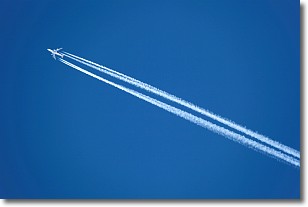
Weather Topic: What are Contrails?
Home - Education - Cloud Types - Contrails
 Next Topic: Cumulonimbus Clouds
A contrail is an artificial cloud, created by the passing of an
aircraft.
Contrails form because water vapor in the exhaust of aircraft engines is suspended
in the air under certain temperatures and humidity conditions. These contrails
are called exhaust contrails.
Another type of contrail can form due to a temporary reduction in air pressure
moving over the plane's surface, causing condensation.
These are called aerodynamic contrails.
When you can see your breath on a cold day, it is also because of condensation.
The reason contrails last longer than the condensation from your breath is
because the water in contrails freezes into ice particles.
Next Topic: Cumulonimbus Clouds
Current conditions powered by WeatherAPI.com


