Weather Alert in North Carolina
Tropical Storm Warning issued August 21 at 4:49AM EDT by NWS Newport/Morehead City NC
AREAS AFFECTED: Mainland Dare
DESCRIPTION: * LOCATIONS AFFECTED - Manns Harbor - East Lake - Stumpy Point * WIND - LATEST LOCAL FORECAST: Below tropical storm force wind - Peak Wind Forecast: 20-30 mph with gusts to 45 mph - THREAT TO LIFE AND PROPERTY THAT INCLUDES TYPICAL FORECAST UNCERTAINTY IN TRACK, SIZE AND INTENSITY: Wind less than 39 mph - The wind threat has decreased from the previous assessment. - PLAN: The sustained wind should remain less than tropical storm force. Conditions may still be gusty. - PREPARE: Listen for any instructions from local officials. - ACT: Ensure emergency readiness should the forecast change. - REALIZED IMPACTS: Being Assessed - Little to no additional wind impacts expected. Community officials are now assessing the extent of actual wind impacts accordingly. * STORM SURGE - No storm surge inundation forecast - THREAT TO LIFE AND PROPERTY THAT INCLUDES TYPICAL FORECAST UNCERTAINTY IN TRACK, SIZE AND INTENSITY: Little to no storm surge flooding - The storm surge threat has remained nearly steady from the previous assessment. - PLAN: There is little to no threat of storm surge flooding. Rough surf, coastal erosion, and life-threatening rip currents are possible. - PREPARE: Little to no preparations for storm surge flooding are needed. - ACT: Follow the instructions of local officials. Monitor forecasts. - POTENTIAL IMPACTS: Little to None - Little to no potential impacts from storm surge flooding. * FLOODING RAIN - LATEST LOCAL FORECAST: - Peak Rainfall Amounts: No additional significant rainfall forecast - THREAT TO LIFE AND PROPERTY THAT INCLUDES TYPICAL FORECAST UNCERTAINTY IN TRACK, SIZE AND INTENSITY: Little or no potential for flooding rain - The flooding rain threat has remained nearly steady from the previous assessment. - PLAN: There is little or no potential for flooding rain. - PREPARE: Little to no preparations are needed to protect against flooding rain at this time. - ACT: Monitor for changes to the forecast. - POTENTIAL IMPACTS: Little to None - Little to no potential impacts from flooding rain. * TORNADO - LATEST LOCAL FORECAST: - Situation is unfavorable for tornadoes - THREAT TO LIFE AND PROPERTY THAT INCLUDES TYPICAL FORECAST UNCERTAINTY IN TRACK, SIZE AND INTENSITY: Tornadoes not expected - The tornado threat has remained nearly steady from the previous assessment. - PLAN: Tornadoes are not expected. Showers and thunderstorms with gusty winds may still occur. - PREPARE: Little to no preparations needed to protect against tornadoes at this time. Keep informed of the latest tornado situation. - ACT: Listen for changes in the forecast. - POTENTIAL IMPACTS: Little to None - Little to no potential impacts from tornadoes. * FOR MORE INFORMATION: - http://ready.gov/hurricanes
INSTRUCTION: N/A
Want more detail? Get the Complete 7 Day and Night Detailed Forecast!
Current U.S. National Radar--Current
The Current National Weather Radar is shown below with a UTC Time (subtract 5 hours from UTC to get Eastern Time).

National Weather Forecast--Current
The Current National Weather Forecast and National Weather Map are shown below.

National Weather Forecast for Tomorrow
Tomorrow National Weather Forecast and Tomorrow National Weather Map are show below.

North America Water Vapor (Moisture)
This map shows recent moisture content over North America. Bright and colored areas show high moisture (ie, clouds); brown indicates very little moisture present; black indicates no moisture.

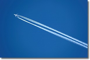
Weather Topic: What are Contrails?
Home - Education - Cloud Types - Contrails
 Next Topic: Cumulonimbus Clouds
A contrail is an artificial cloud, created by the passing of an
aircraft.
Contrails form because water vapor in the exhaust of aircraft engines is suspended
in the air under certain temperatures and humidity conditions. These contrails
are called exhaust contrails.
Another type of contrail can form due to a temporary reduction in air pressure
moving over the plane's surface, causing condensation.
These are called aerodynamic contrails.
When you can see your breath on a cold day, it is also because of condensation.
The reason contrails last longer than the condensation from your breath is
because the water in contrails freezes into ice particles.
Next Topic: Cumulonimbus Clouds
Weather Topic: What are Cumulus Clouds?
Home - Education - Cloud Types - Cumulus Clouds
 Next Topic: Drizzle
Cumulus clouds are fluffy and textured with rounded tops, and
may have flat bottoms. The border of a cumulus cloud
is clearly defined, and can have the appearance of cotton or cauliflower.
Cumulus clouds form at low altitudes (rarely above 2 km) but can grow very tall,
becoming cumulus congestus and possibly the even taller cumulonimbus clouds.
When cumulus clouds become taller, they have a greater chance of producing precipitation.
Next Topic: Drizzle
Current conditions powered by WeatherAPI.com


