Weather Alert in Texas
Flood Warning issued June 12 at 2:53PM CDT until June 14 at 6:54AM CDT by NWS Austin/San Antonio TX
AREAS AFFECTED: Bexar, TX; Wilson, TX
DESCRIPTION: ...Forecast flooding changed from Minor to Moderate severity and increased in duration for the following rivers in Texas... San Antonio River Near Elmendorf affecting Wilson and Bexar Counties. * WHAT...Minor flooding is occurring and moderate flooding is forecast. * WHERE...San Antonio River near Elmendorf. * WHEN...From this afternoon to Saturday morning. * IMPACTS...At 45.0 feet, Moderate lowland flooding inundates crop and pastureland below San Antonio to below Floresville. Roads and bridges in the flood plain are flooded. Pump jacks and oil field tank batteries flood. * ADDITIONAL DETAILS... - At 2:30 PM CDT Thursday the stage was 36.0 feet. - Bankfull stage is 33.0 feet. - Recent Activity...The maximum river stage in the 24 hours ending at 2:30 PM CDT Thursday was 36.0 feet. - Forecast...The river is expected to rise to a crest of 45.5 feet just after midnight tonight. It will then fall below flood stage tomorrow evening. - Flood stage is 35.0 feet. - Flood History...This crest compares to a previous crest of 45.0 feet on 05/24/2015. - http://www.weather.gov/safety/flood
INSTRUCTION: To escape rising water, take the shortest path to higher ground. Motorists should not attempt to drive around barricades or drive cars through flooded areas. Turn around, don't drown when encountering flooded roads. Most flood deaths occur in vehicles. Additional information is available at www.weather.gov. The next statement will be issued Friday morning at 900 AM CDT.
Want more detail? Get the Complete 7 Day and Night Detailed Forecast!
Current U.S. National Radar--Current
The Current National Weather Radar is shown below with a UTC Time (subtract 5 hours from UTC to get Eastern Time).

National Weather Forecast--Current
The Current National Weather Forecast and National Weather Map are shown below.

National Weather Forecast for Tomorrow
Tomorrow National Weather Forecast and Tomorrow National Weather Map are show below.

North America Water Vapor (Moisture)
This map shows recent moisture content over North America. Bright and colored areas show high moisture (ie, clouds); brown indicates very little moisture present; black indicates no moisture.

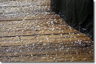
Weather Topic: What is Sleet?
Home - Education - Precipitation - Sleet
 Next Topic: Snow
Sleet is a form of precipitation in which small ice pellets are the primary
components. These ice pellets are smaller and more translucent than hailstones,
and harder than graupel. Sleet is caused by specific atmospheric conditions and
therefore typically doesn't last for extended periods of time.
The condition which leads to sleet formation requires a warmer body of air to be
wedged in between two sub-freezing bodies of air. When snow falls through a warmer
layer of air it melts, and as it falls through the next sub-freezing body of air
it freezes again, forming ice pellets known as sleet. In some cases, water
droplets don't have time to freeze before reaching the surface and the result is
freezing rain.
Next Topic: Snow
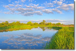
Weather Topic: What are Stratocumulus Clouds?
Home - Education - Cloud Types - Stratocumulus Clouds
 Next Topic: Stratus Clouds
Stratocumulus clouds are similar to altocumulus clouds in their
fluffy appearance, but have a slightly darker shade due to their additional mass.
A good way to distinguish the two cloud types is to hold your hand out and measure
the size of an individual cloud; if it is the size of your thumb it is generally
an altocumulus cloud, if it is the size of your hand it is generally a
stratocumulus cloud.
It is uncommon for stratocumulus clouds to produce precipitation, but if they do
it is usually a light rain or snow.
Next Topic: Stratus Clouds
Current conditions powered by WeatherAPI.com


