Weather Alerts for Colorado
1. Fire Weather Watch for: Upper Arkansas River Valley Including Lake County and Chaffee County; Teller County/Rampart Range Including Pikes Peak and Florissant Fossil Beds National Monument; Fremont County Including Canon City/Howard/Texas Creek; San Luis Valley Including Alamosa/Del Norte/Fort Garland/Saguache; Southern Front Range Including Sangre De Cristo Mountains/Wet Mountains/La Veta Pass; Northern El Paso County Including Monument and Black Forest; Southern El Paso County Including Fort Carson and Colorado Springs; Pueblo County Including Pueblo; Huerfano County Including Walsenburg; Western Las Animas County Including Trinidad and Thatcher; Crowley County Including Ordway; Otero County Including La Junta and Western Comanche Grasslands; Eastern Las Animas County Including Pinon Canyon; Kiowa County Including Eads; Bent County Including Las Animas; Prowers County Including Lamar; Baca County Including Springfield and Eastern Comanche Grasslands
2. Freeze Warning for: Central Colorado River Basin; Four Corners/Upper Dolores River; Animas River Basin; San Juan River Basin
3. Freeze Warning for: Lower Yampa River Basin; Central Yampa River Basin; Debeque to Silt Corridor; Central Gunnison and Uncompahgre River Basin; Paradox Valley/Lower Dolores River; Eastern Uinta Basin
4. Freeze Watch for: Central Colorado River Basin; Four Corners/Upper Dolores River; Animas River Basin; San Juan River Basin
Want more detail? Get the Complete 7 Day and Night Detailed Forecast!
Current U.S. National Radar--Current
The Current National Weather Radar is shown below with a UTC Time (subtract 5 hours from UTC to get Eastern Time).

National Weather Forecast--Current
The Current National Weather Forecast and National Weather Map are shown below.

National Weather Forecast for Tomorrow
Tomorrow National Weather Forecast and Tomorrow National Weather Map are show below.

North America Water Vapor (Moisture)
This map shows recent moisture content over North America. Bright and colored areas show high moisture (ie, clouds); brown indicates very little moisture present; black indicates no moisture.

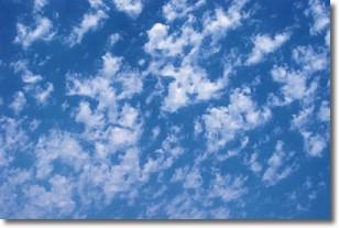
Weather Topic: What are Fractus Clouds?
Home - Education - Cloud Types - Fractus Clouds
 Next Topic: Freezing Rain
A fractus cloud (scud) is a fragmented, tattered cloud which has
likely been sheared off of another cloud. They are accessory clouds, meaning they
develop from parent clouds, and are named in a way which describes the original
cloud which contained them.
Fractus clouds which have originated from cumulus clouds are referred to as
cumulus fractus, while fractus clouds which have originated from stratus clouds
are referred to as stratus fractus. Under certain conditions a fractus cloud might
merge with another cloud, or develop into a cumulus cloud, but usually a
fractus cloud seen by itself will dissipate rapidly.
They are often observed on the leading and trailing edges of storm clouds,
and are a display of wind activity.
Next Topic: Freezing Rain
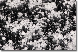
Weather Topic: What is Graupel?
Home - Education - Precipitation - Graupel
 Next Topic: Hail
Graupel is a form of precipitation that is created by atmospheric conditions
which cause supercooled water droplets to contact snow crystals and freeze to
their surface.
Sometimes known as soft hail or snow pellets, graupel is delicate and easily
destroyed by touch. Whereas hail usually falls during severe weather, graupel
doesn't require such conditions to form, and can form in mild precipitation
similar to situations which produce snowfall.
Next Topic: Hail
Current conditions powered by WeatherAPI.com


