Weather Alerts for North Carolina
1. Beach Hazards Statement for: Coastal Onslow
2. Beach Hazards Statement for: East Carteret
3. Beach Hazards Statement for: Eastern Currituck; Virginia Beach
4. Beach Hazards Statement for: Northern Outer Banks; Ocracoke Island; Hatteras Island
5. Beach Hazards Statement for: West Carteret
6. Coastal Flood Advisory for: Coastal Brunswick
7. Coastal Flood Advisory for: Coastal Pender; Coastal New Hanover
8. Coastal Flood Advisory for: Inland New Hanover
9. Coastal Flood Advisory for: Pamlico; Southern Craven
10. Coastal Flood Warning for: Coastal Onslow
11. Coastal Flood Warning for: East Carteret
12. Coastal Flood Warning for: Eastern Currituck; Virginia Beach
13. Coastal Flood Warning for: West Carteret
14. Flood Advisory for: Pender, NC
15. Flood Warning for: Jones, NC; Lenoir, NC
16. Flood Warning for: Robeson, NC
17. High Surf Advisory for: Coastal Brunswick
18. High Surf Advisory for: Coastal Onslow
19. High Surf Advisory for: Coastal Pender; Coastal New Hanover
20. High Surf Advisory for: East Carteret
21. High Surf Advisory for: Eastern Currituck; Virginia Beach
22. High Surf Advisory for: Northern Outer Banks; Ocracoke Island; Hatteras Island
23. High Surf Advisory for: West Carteret
24. Rip Current Statement for: Coastal Pender; Coastal New Hanover
25. Storm Surge Warning for: East Carteret
26. Storm Surge Warning for: Hatteras Island
27. Storm Surge Warning for: Northern Outer Banks
28. Storm Surge Warning for: Ocracoke Island
29. Tropical Cyclone Statement for: Mainland Dare; East Carteret; Northern Outer Banks; Ocracoke Island; Hatteras Island
30. Tropical Cyclone Statement for: Mainland Dare; East Carteret; Northern Outer Banks; Ocracoke Island; Hatteras Island
31. Tropical Storm Warning for: East Carteret
32. Tropical Storm Warning for: Eastern Currituck
33. Tropical Storm Warning for: Hatteras Island
34. Tropical Storm Warning for: Mainland Dare
35. Tropical Storm Warning for: Northern Outer Banks
36. Tropical Storm Warning for: Ocracoke Island
37. Tropical Storm Warning for: Western Currituck
38. Wind Advisory for: Pasquotank; Camden; Norfolk/Portsmouth; Chesapeake; Hampton/Poquoson
Want more detail? Get the Complete 7 Day and Night Detailed Forecast!
Current U.S. National Radar--Current
The Current National Weather Radar is shown below with a UTC Time (subtract 5 hours from UTC to get Eastern Time).

National Weather Forecast--Current
The Current National Weather Forecast and National Weather Map are shown below.

National Weather Forecast for Tomorrow
Tomorrow National Weather Forecast and Tomorrow National Weather Map are show below.

North America Water Vapor (Moisture)
This map shows recent moisture content over North America. Bright and colored areas show high moisture (ie, clouds); brown indicates very little moisture present; black indicates no moisture.

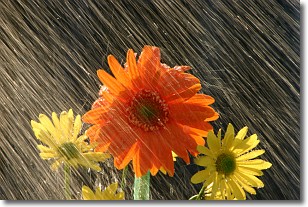
Weather Topic: What is Precipitation?
Home - Education - Precipitation - Precipitation
 Next Topic: Rain
Precipitation can refer to many different forms of water that
may fall from clouds. Precipitation occurs after a cloud has become saturated to
the point where its water particles are more dense than the air below the cloud.
In most cases, precipitation will reach the ground, but it is not uncommon for
precipitation to evaporate before it reaches the earth's surface.
When precipitation evaporates before it contacts the ground it is called Virga.
Graupel, hail, sleet, rain, drizzle, and snow are forms of precipitation, but fog
and mist are not considered precipitation because the water vapor which
constitutes them isn't dense enough to fall to the ground.
Next Topic: Rain
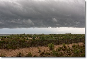
Weather Topic: What are Shelf Clouds?
Home - Education - Cloud Types - Shelf Clouds
 Next Topic: Sleet
A shelf cloud is similar to a wall cloud, but forms at the front
of a storm cloud, instead of at the rear, where wall clouds form.
A shelf cloud is caused by a series of events set into motion by the advancing
storm; first, cool air settles along the ground where precipitation has just fallen.
As the cool air is brought in, the warmer air is displaced, and rises above it,
because it is less dense. When the warmer air reaches the bottom of the storm cloud,
it begins to cool again, and the resulting condensation is a visible shelf cloud.
Next Topic: Sleet
Current conditions powered by WeatherAPI.com


