Weather Alerts for Colorado
1. Air Quality Alert for: Dolores, CO; Montezuma, CO
2. Air Quality Alert for: Garfield, CO; Routt, CO; Mesa, CO; Rio Blanco, CO
3. Air Quality Alert for: Mesa, CO; Routt, CO; Delta, CO; Rio Blanco, CO; Garfield, CO; Gunnison, CO; Montrose, CO
4. Air Quality Alert for: San Juan, CO; Montezuma, CO; San Miguel, CO; Ouray, CO; Dolores, CO; Hinsdale, CO
5. Fire Weather Watch for: Jackson County Below 9000 Feet; South and Southeast Grand/West Central and Southwest Boulder/Gilpin/Clear Creek/Summit/North and West Park Counties Above 9000 Feet; Grand and Summit Counties Below 9000 Feet; Central and Southeast Park County; Larimer and Boulder Counties Between 6000 and 9000 Feet; Jefferson and West Douglas Counties Above 6000 Feet/Gilpin/Clear Creek/Northeast Park Counties Below 9000 Feet; West Jackson and West Grand Counties Above 9000 Feet; South and East Jackson/Larimer/North and Northeast Grand/Northwest Boulder Counties Above 9000 Feet
6. Fire Weather Watch for: Little Snake; White River; Lower Colorado River; Southwest Colorado Lower Forecast Area; Paradox Valley; Northern San Juan; North Fork; Gunnison Basin; Southwest Colorado Upper West Forecast Area; Southwest Colorado Upper East Forecast Area; Eastern Ashley National Forest; Eastern Uintah Basin; Book Cliffs; Colorado River Basin; Southeast Utah
7. Fire Weather Watch for: Little Snake; White River; Lower Colorado River; Southwest Colorado Lower Forecast Area; Paradox Valley; Northern San Juan; North Fork; Gunnison Basin; Southwest Colorado Upper West Forecast Area; Southwest Colorado Upper East Forecast Area; Eastern Ashley National Forest; Eastern Uintah Basin; Book Cliffs; Colorado River Basin; Southeast Utah
8. Fire Weather Watch for: Routt; Colorado River Headwaters
9. Fire Weather Watch for: Routt; Colorado River Headwaters
10. Fire Weather Watch for: Upper Arkansas River Valley Including Lake County and Chaffee County; Fremont County Including Canon City/Howard/Texas Creek; Eastern San Juan Mountains and La Garita Mountains Including Wolf Creek Pass and Creede; Southern Front Range Including Sangre De Cristo Mountains/Wet Mountains/La Veta Pass
11. Red Flag Warning for: Routt; Colorado River Headwaters
Want more detail? Get the Complete 7 Day and Night Detailed Forecast!
Current U.S. National Radar--Current
The Current National Weather Radar is shown below with a UTC Time (subtract 5 hours from UTC to get Eastern Time).

National Weather Forecast--Current
The Current National Weather Forecast and National Weather Map are shown below.

National Weather Forecast for Tomorrow
Tomorrow National Weather Forecast and Tomorrow National Weather Map are show below.

North America Water Vapor (Moisture)
This map shows recent moisture content over North America. Bright and colored areas show high moisture (ie, clouds); brown indicates very little moisture present; black indicates no moisture.

Weather Topic: What is Fog?
Home - Education - Cloud Types - Fog
 Next Topic: Fractus Clouds
Fog is technically a type of stratus cloud, which lies along the
ground and obscures visibility.
It is usually created when humidity in the air condenses into tiny water droplets.
Because of this, some places are more prone to foggy weather, such as regions
close to a body of water.
Fog is similar to mist; both are the appearance of water droplets suspended in
the air, but fog is the term applied to the condition when visibility is less than 1 km.
Next Topic: Fractus Clouds
Weather Topic: What is Freezing Rain?
Home - Education - Precipitation - Freezing Rain
 Next Topic: Graupel
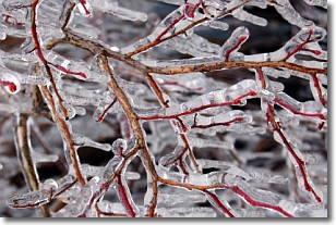
Freezing rain is a condition where precipitation which has fallen in the form of
water droplets reaches temperatures which are below freezing and freezes upon
coming into contact
with surface objects. The result of this precipitation is a glaze of ice which
can be damaging to plants and man-made structures. A severe onset of freezing
rain which results in a very thick glaze of ice is known as an ice storm.
Next Topic: Graupel
Current conditions powered by WeatherAPI.com


