Weather Alerts for Oregon
1. Extreme Heat Warning for: Eastern Curry County and Josephine County; Jackson County
2. Extreme Heat Warning for: Lower Columbia River; Tualatin Valley; West Hills and Chehalem Mountains; Inner Portland Metro; East Portland Metro; Outer Southeast Portland Metro; West Central Willamette Valley; East Central Willamette Valley; Benton County Lowlands; Linn County Lowlands; Lane County Lowlands; West Columbia River Gorge of Oregon above 500 ft; West Columbia River Gorge I-84 Corridor; Upper Hood River Valley; Central Columbia River Gorge I-84 Corridor; Clackamas County Cascade Foothills; Cascade Foothills of Marion and Linn Counties; Lane County Cascade Foothills; Cowlitz County Lowlands; North Clark County Lowlands; Inner Vancouver Metro; East Clark County Lowlands; West Columbia River Gorge - SR 14; Central Columbia River Gorge - SR 14
3. Extreme Heat Watch for: Eastern Columbia River Gorge of Oregon; Lower Columbia Basin of Oregon; Foothills of the Northern Blue Mountains of Oregon; Foothills of the Southern Blue Mountains of Oregon; North Central Oregon; Eastern Columbia River Gorge of Washington; Kittitas Valley; Yakima Valley; Lower Columbia Basin of Washington; Foothills of the Blue Mountains of Washington; Simcoe Highlands; Lower Slopes of the Eastern Washington Cascades Crest
4. Heat Advisory for: Central Douglas County; Eastern Douglas County Foothills
5. Heat Advisory for: North Oregon Coast Range Lowlands; Central Oregon Coast Range Lowlands; North Oregon Cascades; Cascades of Marion and Linn Counties; Cascades of Lane County; Willapa and Wahkiakum Lowlands; South Washington Cascade Foothills; South Washington Cascades
6. Red Flag Warning for: Southern Willamette Valley
7. Red Flag Warning for: Warm Springs Reservation
8. Special Weather Statement for: East Portland Metro; West Columbia River Gorge of Oregon above 500 ft; West Columbia River Gorge I-84 Corridor; Central Columbia River Gorge I-84 Corridor; East Clark County Lowlands; West Columbia River Gorge - SR 14; Central Columbia River Gorge - SR 14; South Washington Cascades
Want more detail? Get the Complete 7 Day and Night Detailed Forecast!
Current U.S. National Radar--Current
The Current National Weather Radar is shown below with a UTC Time (subtract 5 hours from UTC to get Eastern Time).

National Weather Forecast--Current
The Current National Weather Forecast and National Weather Map are shown below.

National Weather Forecast for Tomorrow
Tomorrow National Weather Forecast and Tomorrow National Weather Map are show below.

North America Water Vapor (Moisture)
This map shows recent moisture content over North America. Bright and colored areas show high moisture (ie, clouds); brown indicates very little moisture present; black indicates no moisture.

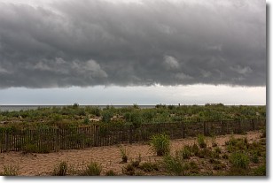
Weather Topic: What are Shelf Clouds?
Home - Education - Cloud Types - Shelf Clouds
 Next Topic: Sleet
A shelf cloud is similar to a wall cloud, but forms at the front
of a storm cloud, instead of at the rear, where wall clouds form.
A shelf cloud is caused by a series of events set into motion by the advancing
storm; first, cool air settles along the ground where precipitation has just fallen.
As the cool air is brought in, the warmer air is displaced, and rises above it,
because it is less dense. When the warmer air reaches the bottom of the storm cloud,
it begins to cool again, and the resulting condensation is a visible shelf cloud.
Next Topic: Sleet
Weather Topic: What is Snow?
Home - Education - Precipitation - Snow
 Next Topic: Stratocumulus Clouds
Snow is precipitation taking the form of ice crystals. Each ice crystal, or snowflake,
has unique characteristics, but all of them grow in a hexagonal structure.
Snowfall can last for sustained periods of time and result in significant buildup
of snow on the ground.
On the earth's surface, snow starts out light and powdery, but as it begins to melt
it tends to become more granular, producing small bits of ice which have the consistency of
sand. After several cycles of melting and freezing, snow can become very dense
and ice-like, commonly known as snow pack.
Next Topic: Stratocumulus Clouds
Current conditions powered by WeatherAPI.com


