Weather Alerts for Wyoming
1. Avalanche Warning for: Star Valley; Salt River and Wyoming Ranges
2. High Wind Warning for: Central Laramie County
3. High Wind Warning for: Central Laramie Range and Southwest Platte County
4. High Wind Warning for: East Laramie County
5. High Wind Warning for: East Platte County
6. High Wind Warning for: Ferris/Seminoe/Shirley Mountains; Shirley Basin; Central Carbon County
7. High Wind Warning for: Goshen County
8. High Wind Warning for: Green Mountains and Rattlesnake Range; Natrona County Lower Elevations
9. High Wind Warning for: Laramie Valley
10. High Wind Warning for: North Snowy Range Foothills
11. High Wind Warning for: South Laramie Range; South Laramie Range Foothills
12. High Wind Warning for: South Lincoln County; Rock Springs and Green River; Flaming Gorge; East Sweetwater County
13. High Wind Warning for: Upper North Platte River Basin
14. High Wind Warning for: Wind River Basin
15. High Wind Warning for: Wind River Mountains East; Upper Wind River Basin
16. High Wind Watch for: Absaroka Mountains
17. High Wind Watch for: Cody Foothills
18. Winter Storm Warning for: Absaroka Mountains
19. Winter Storm Warning for: Sierra Madre Range; Snowy Range
20. Winter Storm Warning for: Teton and Gros Ventre Mountains; Salt River and Wyoming Ranges
21. Winter Storm Warning for: Wind River Mountains West
22. Winter Storm Warning for: Yellowstone National Park
23. Winter Weather Advisory for: Bighorn Mountains West; Bighorn Mountains Southeast
Want more detail? Get the Complete 7 Day and Night Detailed Forecast!
Current U.S. National Radar--Current
The Current National Weather Radar is shown below with a UTC Time (subtract 5 hours from UTC to get Eastern Time).

National Weather Forecast--Current
The Current National Weather Forecast and National Weather Map are shown below.

National Weather Forecast for Tomorrow
Tomorrow National Weather Forecast and Tomorrow National Weather Map are show below.

North America Water Vapor (Moisture)
This map shows recent moisture content over North America. Bright and colored areas show high moisture (ie, clouds); brown indicates very little moisture present; black indicates no moisture.

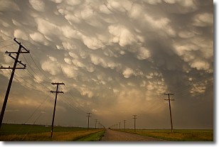
Weather Topic: What are Mammatus Clouds?
Home - Education - Cloud Types - Mammatus Clouds
 Next Topic: Nimbostratus Clouds
A mammatus cloud is a cloud with a unique feature which resembles
a web of pouches hanging along the base of the cloud.
In the United States, mammatus clouds tend to form in the warmer months, commonly
in the Midwest and eastern regions.
While they usually form at the bottom of a cumulonimbis cloud, they can also form
under altostratus, altocumulus, stratocumulus, and cirrus clouds. Mammatus clouds
warn that severe weather is close.
Next Topic: Nimbostratus Clouds
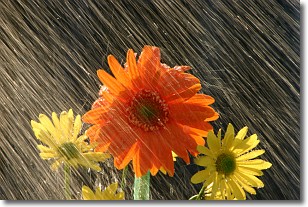
Weather Topic: What is Precipitation?
Home - Education - Precipitation - Precipitation
 Next Topic: Rain
Precipitation can refer to many different forms of water that
may fall from clouds. Precipitation occurs after a cloud has become saturated to
the point where its water particles are more dense than the air below the cloud.
In most cases, precipitation will reach the ground, but it is not uncommon for
precipitation to evaporate before it reaches the earth's surface.
When precipitation evaporates before it contacts the ground it is called Virga.
Graupel, hail, sleet, rain, drizzle, and snow are forms of precipitation, but fog
and mist are not considered precipitation because the water vapor which
constitutes them isn't dense enough to fall to the ground.
Next Topic: Rain
Current conditions powered by WeatherAPI.com


