Weather Alerts for Alaska
1. Special Weather Statement for: Lower Yukon River; Lower Yukon and Innoko Valleys; North Slopes of the Western Alaska Range; Upper Kuskokwim Valley
2. Special Weather Statement for: Northern Seward Peninsula; Southern Seward Peninsula Coast; Interior Seward Peninsula
3. Special Weather Statement for: South Slopes Of The Central Brooks Range; Upper Koyukuk Valley; Central Interior
4. Special Weather Statement for: Upper Kobuk Valleys; Lower Koyukuk Valley
5. Special Weather Statement for: White Mountains and High Terrain South of the Yukon River; Upper Chena River Valley; Tanana Flats; Eielson AFB and Salcha; Goldstream Valley and Nenana Hills; Chatanika River Valley; Two Rivers; Fairbanks Metro Area; Nenana; Northern Denali Borough
6. Wind Advisory for: Eastern Alaska Range North of Trims Camp
7. Winter Storm Warning for: Kuskokwim Delta Coast and Nunivak Island
8. Winter Storm Warning for: Yukon Delta Coast
9. Winter Storm Watch for: Dalton Highway Summits
10. Winter Storm Watch for: Eastern Alaska Range South of Trims Camp
11. Winter Storm Watch for: Eastern Norton Sound and Nulato Hills
12. Winter Storm Watch for: Middle Yukon Valley
13. Winter Storm Watch for: St Lawrence Island
14. Winter Weather Advisory for: Eastern Alaska Range South of Trims Camp
15. Winter Weather Advisory for: Kuskokwim Valley West; Kuskokwim Valley East; Lime Village; Interior Kuskokwim Delta
Want more detail? Get the Complete 7 Day and Night Detailed Forecast!
Current U.S. National Radar--Current
The Current National Weather Radar is shown below with a UTC Time (subtract 5 hours from UTC to get Eastern Time).

National Weather Forecast--Current
The Current National Weather Forecast and National Weather Map are shown below.

National Weather Forecast for Tomorrow
Tomorrow National Weather Forecast and Tomorrow National Weather Map are show below.

North America Water Vapor (Moisture)
This map shows recent moisture content over North America. Bright and colored areas show high moisture (ie, clouds); brown indicates very little moisture present; black indicates no moisture.

Weather Topic: What are Nimbostratus Clouds?
Home - Education - Cloud Types - Nimbostratus Clouds
 Next Topic: Precipitation
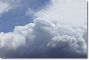
A nimbostratus cloud is similar to a stratus cloud in its formless,
smooth appearance. However, a nimbostratus cloud is darker than a stratus cloud,
because it is thicker.
Unlike a stratus cloud, a nimbostratus cloud typically brings with it the threat
of moderate to heavy precipitation. In some cases, the precipitation may evaporate
before reaching the ground, a phenomenon known as virga.
Next Topic: Precipitation
Weather Topic: What is Rain?
Home - Education - Precipitation - Rain
 Next Topic: Shelf Clouds
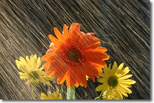
Precipitation in the form of water droplets is called rain.
Rain generally has a tendency to fall with less intensity over a greater period
of time, and when rainfall is more severe it is usually less sustained.
Rain is the most common form of precipitation and happens with greater frequency
depending on the season and regional influences. Cities have been shown to have
an observable effect on rainfall, due to an effect called the urban heat island.
Compared to upwind, monthly rainfall between twenty and forty miles downwind of
cities is 30% greater.
Next Topic: Shelf Clouds
Current conditions powered by WeatherAPI.com


